
Sunday, July 31, 2016
Ringing The Bell At CHS
When the commemorative bell tower was finished at Covington High School and the dedication ceremonies were over, dozens of people, alumni, community leaders, young folks, and older folks all lined up to give a rope a tug. They wanted to take part in the ringing of the bell that was rescued from the disastrous 1970's fire. The bell ringing lasted nearly an hour, as people enjoyed memories of friends, classmates, and events across the decades at Covington's only high school.

Saturday, July 30, 2016
Light At The End of the Tunnel
The light at the end of the tunnel looks promising when that tunnel is on the Blue Ridge Parkway in the North Carolina mountains in mid-Autumn.
Click on the image to see a larger version.

Click on the image to see a larger version.

Friday, July 29, 2016
Hancock County Pictorial Map
Here is the Hancock County Pictorial Map I drew in 1991 for A.G. Crowe. It features Bay St. Louis and Waveland, Mississippi.
Hancock County was named after John Hancock. It was formed in December, 1812, from the West Florida territory. Bay St. Louis became incorporated in February, 1838, first known as Shieldsborough. Waveland was organized in March of 1888 when it was granted a municipal charter. The area has a history rich and colorful as a popular resort and summer retreat.
Click on the image for a larger version.

Wednesday, July 27, 2016
The Friendly Geese
Jake and Rose were two geese who lived near my parent's house in Dupont, LA. They would always come over to the fence to say hello when I came for a visit. Click on the image for a larger view.


Tuesday, July 26, 2016
Carnival at the Theater
In 1970 Southeastern Louisiana University produced the Broadway musical "Carnival," and I was asked to write the program content. It was an enjoyable assignment, because I have always been amazed by the result when a large number of people with different skills come together and make a theater production happen. "Carnival" is certainly an excellent example of that, because not only is it theater, it is music, choreography, circus and a little bit of magic all thrown together.
Here's the program content, filled with a lot of local names and backgrounds. There are two pages. Click on the images to make them appear larger.
Page One

Page Two

Here's the program content, filled with a lot of local names and backgrounds. There are two pages. Click on the images to make them appear larger.
Page One

Page Two

Monday, July 25, 2016
New Orleans 1975
Another photograph I took on my 1975 aerial tour of the area was that of downtown New Orleans. In the picture below, you can tell it's 1975 by the fact that there is only one Mississippi River bridge, no arena, no Hilton Hotel, no Riverwalk and no Westin Canal Place. The Rivergate Convention Center is still there, but the Aquarium hasn't been built yet. Click on the image to make it larger.


This was before the 1984 World's Fair along the Riverfront took down many of the wharf warehouses and put up the large number of exhibition buildings for the fair, some of which became part of the Riverwalk shopping mall.
Sunday, July 24, 2016
Horse Riding On The Lakefront
When this article appeared in the Times Picayune many years ago, I thought it was a great account of the Mandeville lakefront and how people buy old houses and fix them up. Then I noticed the picture of the man riding the horse under the oak trees, and it turned out to be my stepbrother. What a shock that was. I haven't seen him in 40 years and there he is in the newspaper riding a horse at one of my favorite places. You never know who you'll see in the papers (or on Facebook) these days.


Saturday, July 23, 2016
Rainbow At Skipper Stadium
After visiting Mandeville High School one afternoon, as I was driving out of the parking lot, I noticed a rainbow in the sky right above Skipper Stadium. One end of it appeared to be going right down into the middle of the playing field. I took a picture and hoped the pot of gold at the end of the rainbow wouldn't interfere with the next football game.


Friday, July 22, 2016
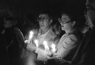
Late Night French Quarter
Visiting the French Quarter at night can be an adventure. Here are some photos I took of a visit that several friends and I took one night in 1972, including a candlelight vigil that was taking place in Jackson Square. Click on the images to make them larger.


Thursday, July 21, 2016
Amite City Maps
Here are two maps I produced of Amite City, north of Hammond, one looking towards the northwest and the other looking towards the northeast. Click on the images for a larger version.


Wednesday, July 20, 2016
Nighttime Drive Through Covington
First you put your camera on manual shutter mode, mount it to the dashboard of your car, and start driving through downtown Covington. You then open the shutter and ten seconds later, you close the shutter, And this is what the result looks like.
These pictures were taken in the early 1970's. If you look closely, you can see the illuminated Goodyear sign in front of Blossman Oil. Click on the images to make them larger.


These pictures were taken in the early 1970's. If you look closely, you can see the illuminated Goodyear sign in front of Blossman Oil. Click on the images to make them larger.


Tuesday, July 19, 2016
SLU Speaker Interviewed
Here's an article I wrote after interviewing a speaker at Southeastern Louisiana University in 1970. He had some interesting comments about life and death. Click on the image below for a more readable size.


Monday, July 18, 2016
Bright Blue Frog Bean Bag
One day I was visiting Polly Anderson's shop on Claiborne Hill, and I noticed she had several frog-shaped bean bags for sale. So I bought one and told her I would take it to the ChefSoiree fund-raising event with me the next day.
At the Chef Soiree I walked in the gate with this bright blue frog bean bag draped over my shoulder, and I thought I would be getting some strange stares. But, no, everyone thought it was great and wanted to know what it was and where they could buy one. I should have brought business cards for the shop.

At the Chef Soiree I walked in the gate with this bright blue frog bean bag draped over my shoulder, and I thought I would be getting some strange stares. But, no, everyone thought it was great and wanted to know what it was and where they could buy one. I should have brought business cards for the shop.

Sunday, July 17, 2016
Water or Stone?
This picture was taken near Hot Springs, Arkansas. On first look, it appears to be the surface of some kind of translucent rock, but it is actually the surface of a lake being churned by the sightseeing boat I was riding on. Click on the image to see a larger version.


Columbiana, AL, Pictorial Map
Here's the map I drew of Columbiana, Alabama, in 1988. Click on the images below to make them larger.


Saturday, July 16, 2016
Ode To The Front Porch
The front porch is that transition zone from someone's home and the rest of the world. It's not quite as comfortable as the air-conditioned interior of the house, but a bit more relaxed than the hustle and bustle of the street, the town and the city that lie beyond the railing. Here's something I wrote to memorialize the importance of taking time on the front porch. Click on the image to enlarge the view.


Hard Place To Take Root
Some trees are located in the middle of big grassy fields. Other trees take other routes, like the one pictured here, which has to put up with big rocks as close personal friends.


Friday, July 15, 2016
Mandeville Market
Every Saturday a large number of people converge on the Mandeville Farmers Market (and Crafts Gallery) at the Tammany Trace Trailhead in Mandeville. Here's a photo.


Pictorial Map of Pell City
In 1990, I drew a map of Pell City, Alabama, which was celebrating its Centennial. Click on the image to make it larger.


Thursday, July 14, 2016
Purvis, MS, Pictorial Map 1987
Here's the pictorial map of downtown Purvis, Mississippi, drawn in 1987. Click on the image to see a larger version.


Jumping The Gap
Before they built the new seawall at the Mandeville Lakefront, say around 1972, there were plenty of gaps in the wall. Water would slosh in through the gaps and erode away the grass and soil behind the seawall.

Some of the gaps were pretty wide, and that made it more difficult to jump across them.


Some of the gaps were pretty wide, and that made it more difficult to jump across them.

Wednesday, July 13, 2016
Shrimp Boat On The Bayou
This picture was taken on a trip down to Galliano, Louisiana. There are a lot of shrimp and oyster boats docked along the bayou there, and this is one of them.


Cradle To The Cross Map
The New Zion Baptist Church on Hwy. 40 between Folsom and Barker's Corner asked me to do a map for their annual "Cradle to The Cross" presentation, a chronological depiction of the major events in the life of Jesus. Here is the map.Click on the image to see a larger version.


Tuesday, July 12, 2016
Eric Hopper, Artist
Eric Hopper was an artist I met at a church in Covington where he was giving a talk. While making his presentation, he would draw a picture on a large board using fluorescent chalk. At the end of the talk, they would turn the lights out and he would turn on a bank of ultraviolet lights. The result would be quite dramatic. The whole drawing would glow. He also did regular paintings, many with a religious theme.
Here are a couple of black and white pictures I took of him while he was drawing. I don't like to use flash while people are speaking, so these are available light only, which actually turned out okay.


Here are a couple of black and white pictures I took of him while he was drawing. I don't like to use flash while people are speaking, so these are available light only, which actually turned out okay.


Monday, July 11, 2016
Historical Society Information Booth
Here's a photograph of Mrs. Amos "Bertha" Neff, parish archivist, and I sitting at the St. Tammany Historical Society's information booth at a community exhibition event.


Writing Novels with Gafferty
In 1994, I read the Celestine Prophecy. It was a good story but kind of new agey with lots of supernatural inferences. I wished it had more solid information about the new discoveries being made in the field of health and the human body.
It didn't, so I wrote "The Gafferty Perspective," a novel about a man who goes on a quest and keeps coming across weird information and people who believe it. So, pretty much the same format as Celestine, but with a more grounded approach. It tells the story of medical researcher Gerald Gaffety and his theory about human health, particularly the need for keeping cells happy. There was some DNA speculation and energy medicine ideas thrown in as well.
I published it myself in 1997. The book was characterized as "science fiction" because, well, some of the information in it was hard to believe, and it was definitely populated with fictional characters.
The first novel "The Gafferty Perspective" was quickly followed by its sequel, "The Gafferty Momentum," written in just a month, probably off the momentum created by writing the first novel (and thus its name.)

Friday, July 8, 2016
Sky Photos
Every so often I take a picture of the sky. Here are three of the more interesting photographs. Click on the images to make them appear larger.


Bay St. Louis Auto Supply Map
Once in a while someone would have me do a map of their building. Here's an auto supply and repair shop from Waveland/Bay St. Louis, Mississippi.


Thursday, July 7, 2016
Baton Rouge Pictorial Map
In 1987 I produced a pictorial map of downtown Baton Rouge, quite a challenge when you think about the large number of buildings. The solution was just to leave most of them out, unfortunately. Here is the map with the key buildings and general information about the capital city of Louisiana.


Wednesday, July 6, 2016
Red Bluff Scenic Outlook
An hour and a half from Covington, north of Bogalusa near Columbia, Mississippi, is a place called Morgantown. It's a small place, on the west side of the Pearl River, lying on either side of the railroad track between Foxworth and Monticello, MS.
Then, just two miles north of Morgantown on Hwy. 587, is Red Bluff, a scenic overlook from which you can see miles and miles, plus one of the most colorful eroded bluffs you can ever imagine. It's been a favorite picnic spot for years, and the erosion is ongoing, so one has to be careful where one stands. The colors are magnificent, and they change depending on how much sunshine and overcast sky there is.
Click on the images below to make them larger.

The erosion is so active, in fact, that the road running by the west side of Red Bluff caves in every so often, and the highway department kept having to move it back. A few years ago, the state finally said "enough is enough" and they moved the highway several hundred yards to the west, away from the bluff, and to get to Red Bluff now you have to turn off the new highway and access the old section of highway that is, sure enough, caving in as we speak.


When you get out of your car you are tempted to walk right up to the edge and stare. But, be careful, because after you do that, often you walk around to the side and, looking back at the edge where you were standing, you notice that there was nothing under you but a big clunk of dirt suspended into space. The terra firma under you had been eroded away. If you bring small children, attach a leash to them before you get out of the car.
Take pictures and enjoy. Here are some pictures of what it looks like, but like the Grand Canyon, pictures actually do not do it justice. There's a person standing on the edge in the picture below; if you can find the person it will give you an idea of how big the bluffs are. Click on the images to make them larger.


To view a YouTube video featuring aerial drone photography of Red Bluff captured by
S&J 3D Concepts, LLC
CLICK BELOW
Aerial View from Google Maps

Subscribe to:
Posts (Atom)